

This railroad became part of the Chicago, Milwaukee & St. Paul in 1872. The CM&StP (Milwaukee Road) had already constructed a line from Sabula, to Chicago.
By 1881, the Milwaukee Road continued to build west. A new line would be constructed through towns such as Toledo, Huxley, Madrid and Perry.
In 1882, the railroad continued to build west through more towns, such as Coon Rapids, Manning and Neola.
By the end of 1882, the railroad finally reached Council Bluffs.
Although the long mainline was completed, it had many issues. Bridges were not built to standard, curves were an issue; and specifically in the western part of Iowa, grades were atrocious.
Chief Engineer Charles Loweth began to address the problems in 1912. Fresh off of the Pacific Expansion, a veteran team helped redesign two mainlines: Minnesota and Iowa.
The expansion also added the "Pacific" to the title, creating the CMStP&P.
While the Minnesota line presented a fairly straightforward situation, the Iowa line presented more challenges.
The eastern portion of the state was simple, with slight grade and route changes. However, the western portion of the state required many route changes, grade reductions and large bridges.
272 Miles would be completed by 1914, between Green Island, Iowa and Manilla, Iowa. This line featured sleek curves, reduced grades and a top class double track line.
In addition, the remaining track between Manilla and Council Bluffs would also be improved.
However, these expansions quickly were realized as too ambitious. Significant portions of the double track were pulled up. Sections included:
Templeton to Herndon and Newhall to Collins were reduced to single track in 1934. Paralta to Green Island was reduced in 1950, and Madrid to Collins in 1956.
Despite a fairly solid traffic base, the Milwaukee Road was oftentimes in trouble financially. At this point, a mass abandonment was court ordered for the Milwaukee Road. 791 miles in Iowa would be abandoned, including the entire Council Bluffs line.
However, some sections were kept intact. Burlington Northern purchased the line from Council Bluffs to Bayard. This is now the BNSF Bayard Subdivision. BNSF was formed from a merger of the Atchison, Topeka & Santa Fe and Burlington Northern in 1996.
In addition, Chicago & North Western was sold the line from Woodward to Slater, and from Herndon to Perry.
C&NW became part of Union Pacific in 1995. In 2003, the Woodward section was abandoned. In 2004, the Perry to Dawson section was abandoned. The Herndon section was abandoned in 1999.
In addition to the Bayard Subdivision, the Raccoon River Valley Trail and High Trestle Trail also utilize portions of this line.
06/16/22
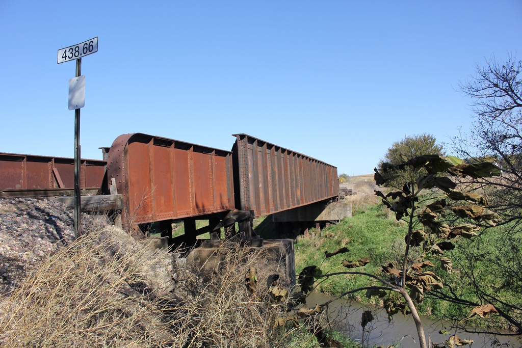
This large through girder bridge crosses Mosquito Creek south of Earling, along Iowa Highway 191.
The previous bridge at this location consisted of a pair of 55-foot through girder spans and a 45-foot through girder span, which were reportedly built in 1927. In 1949, the bridge was replaced by the present bridge, which included bringing in a large 111-foot through girder, and adding two short through girder spans, cut down from another span. These spans were then placed on concrete and timber piers.
It is possible that the original 45-foot girder was reused and cut in half to form the approaches, or it is possible that the spans came from elsewhere and were cut out of separate spans. The north approach boasts a 1913 plaque, while the south span has an empty Wisconsin Bridge & Iron Works plaque location. It is assumed that this span was also constructed between 1910 and 1915. Research on this bridge is ongoing,.
Overall, the bridge appears to be in good condition.
The author has ranked this bridge as being moderately significant, due to the inventive reuse of two girder spans.
The photo above is an overview.